Preamble
Preamble
Different field trips are proposed in the high Val d'Hérens, some (field trips A, B and C) are marked out along the paths (poles with red tags) and their description can be found in purchasable booklets at the «Office du tourisme» in Evolène or at the geological house in Les Haudères. The excursions itineraries can also be downloaded as PDF on: evolene-geologie.ch. This mobile app features field trips A, B, E and H, other field trips will be added in future updates.
How to use this app
Five tabs at the bottom of the screen allow you to navigate through the contents:
- The General tab describes the application.
- The Trips tab provides access to the list of various field trips available in the app.
The Map tab displays an interactive map of the field trips and various stops. (touch here to display available functionalities)
Stops:
The stops are featured as numbered circles. Clicking on one of them will display the related description. From the description you can go back to the stops list by using the return button.Localization:
If you have authorized the application to localize your mobile, your position can be displayed as a blue dot on the map by clicking on the left-hand side "arrow" button. The position is continuously updated (the button turns green) as long as the signal is not lost or you turn the localization off by clicking on the button again (it turns blue again).Zoom:
Using the + and - buttons on the left-hand side, you can zoom or de-zoom the map. It is also possible to zoom using the fingers.Navigation:
You can navigate the map by sliding your fingers on it.Coordinates:
Holding a finger on the map will display a marker giving the aimed coordinates. It is possible to move the marker around with a finger, coordinates will be updated.Icons:
It is possible to show/hide information on the map using the upper right button.
- The Stop tab provides access to all stops from all field trips.
- The Others tab gives access to the app options, a glossary, and various useful informations, the credits and a way to provide feedback.
- Most images in the app can be opened by touching them. It is then possible to zoom in the image by "double tapping" and then navigating with the fingers.
More informations
Field trip descriptions use notions from the introduction to the Val d’Hérens geology where all basic notions on local geology are explained.
These field trips offer an initiation to landscape reading, in particular to what is found under the landforms in front of us. This recent geological relief (a few thousand years) was produced by the erosion of the glaciers. Supporting this, much older rocks are found, they take us for a trip back in time over hundreds of millions years (Ma). The problem on the field is to recognize what is related to the recent glaciations and what belongs to the older geological history. Glaciers have moved rocks all over the valleys, erratic blocks were displaced over tens or even hundreds of kilometers, and these blocks are now juxtaposed to rock outcrops.
The size of the erratic blocks (usually of meter size) allows to distinguish them from rock outcrops that extend over hundreds of meters.
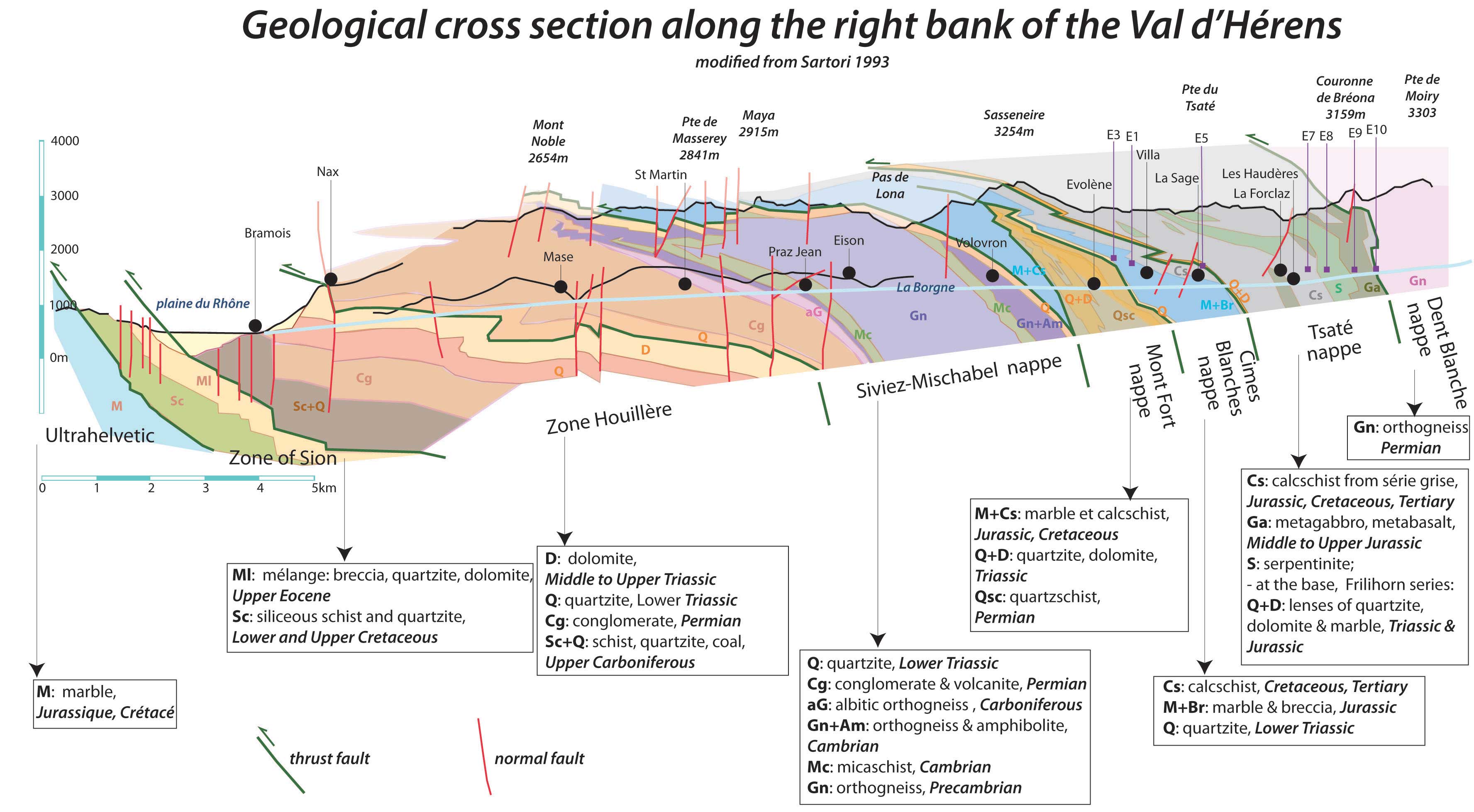
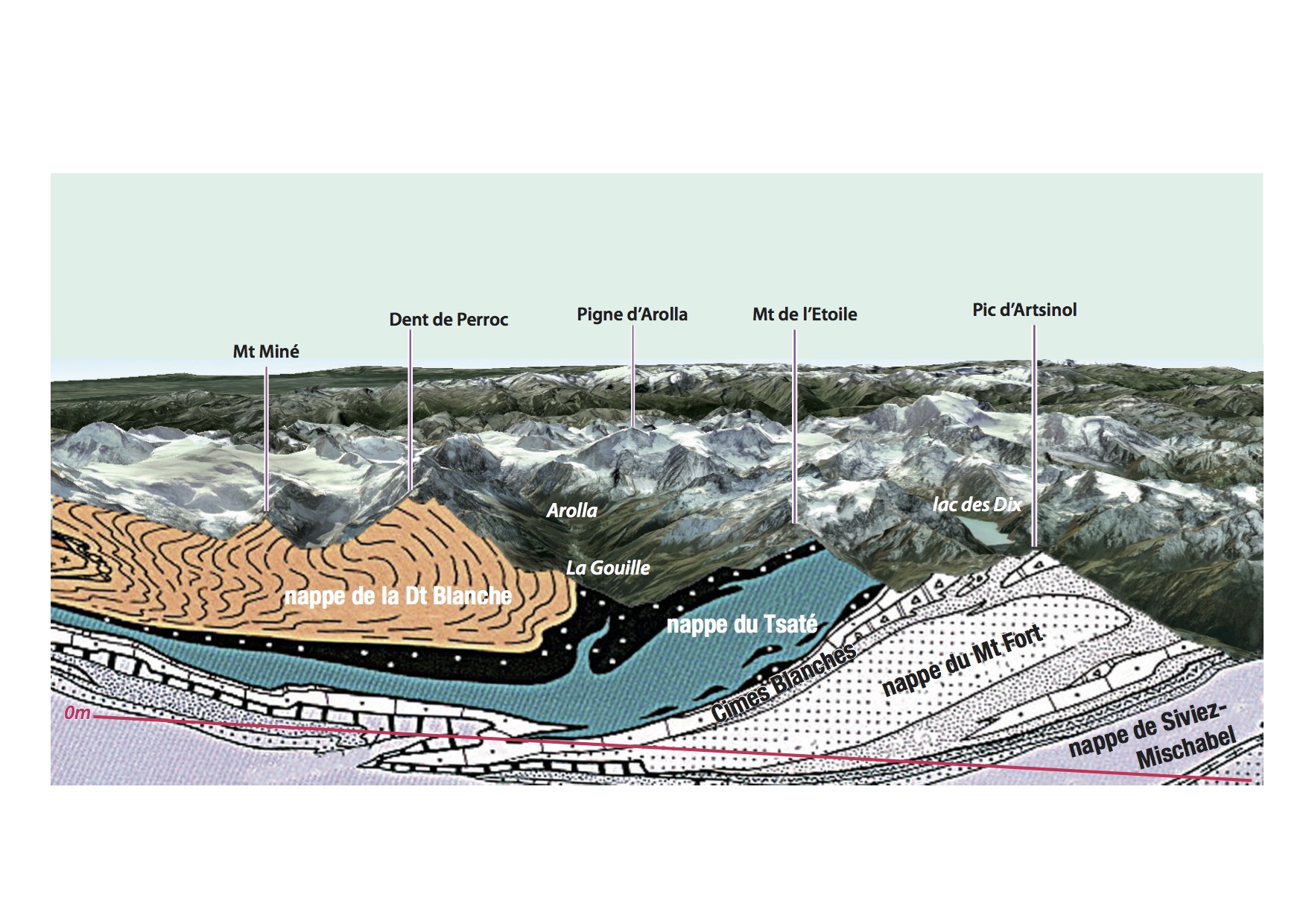
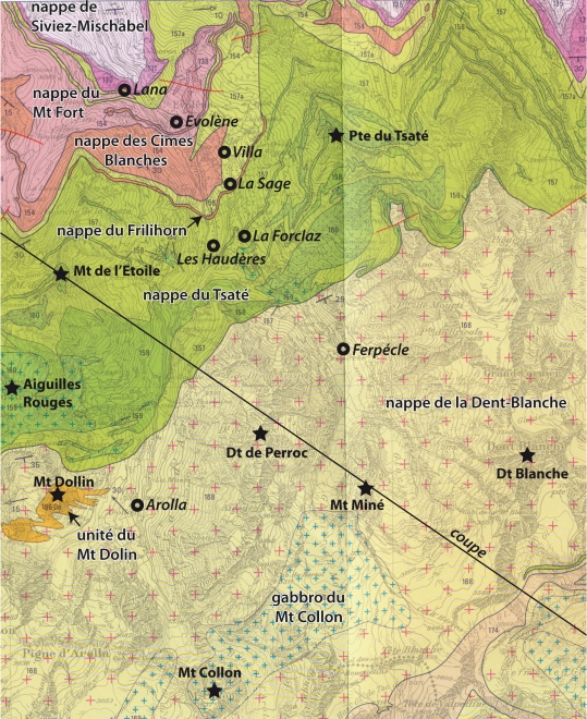
The solution to these problems is found in the determination of the rocks in front of us, mainly if one has a geological map at hand and geological cross-sections that tell us what is supposed to be there. For example, if one is in the Tsaté nappe (made of calcschists, prasinites and serpentinite) and a block of gneiss is found, then it is obvious that the latter is an erratic block derived from the Dent-Blanche massif.
How to determine the rock types in front of us? It is a relatively long learning process depending on the rock type, but guidebooks can be bought or websites consulted, such as objectif roche (Adobe Flash required!). More general informations on earth's dynamics can be found on http://objectif-terre.unil.ch. And many documents on the Val d'Hérens (articles, pictures, data,...) are available on http://ebibalpin.unil.ch/.
Also the description of each stop of the field trip explains what type(s) of rocks are found there, and a integrated glossary defines various terms and rock types.
Tectonic map of the occidental Swiss Alps. Office fédéral des eaux et de la géologie. Berne.